Typhoon Neoguri approaches
I am still catching up on my tourist-ing blogging, but I'd like to take a break from that to discuss the impending typhoon Neoguri. I have received questions from friends and family asking about my status which leads me to believe that this typhoon is getting good press back in the states. I guess the term "super typhoon" is pretty catchy.


Predicted path of Neoguri and my location in Hiroshima. As you can see we will have somewhere between a category 1 typhoon or a severe tropical storm.
So far, Neoguri has hit the southern Japanese Islands and is forecasted to make landfall on the southernmost "main island" of Kyushu later tonight. We are in the predicted path of the storm, and are likely going to receive heavy rainfall and some strong winds. I will be monitoring the Hiroshima Prefecture's weather advisory website to see how the rain and winds impact the area.
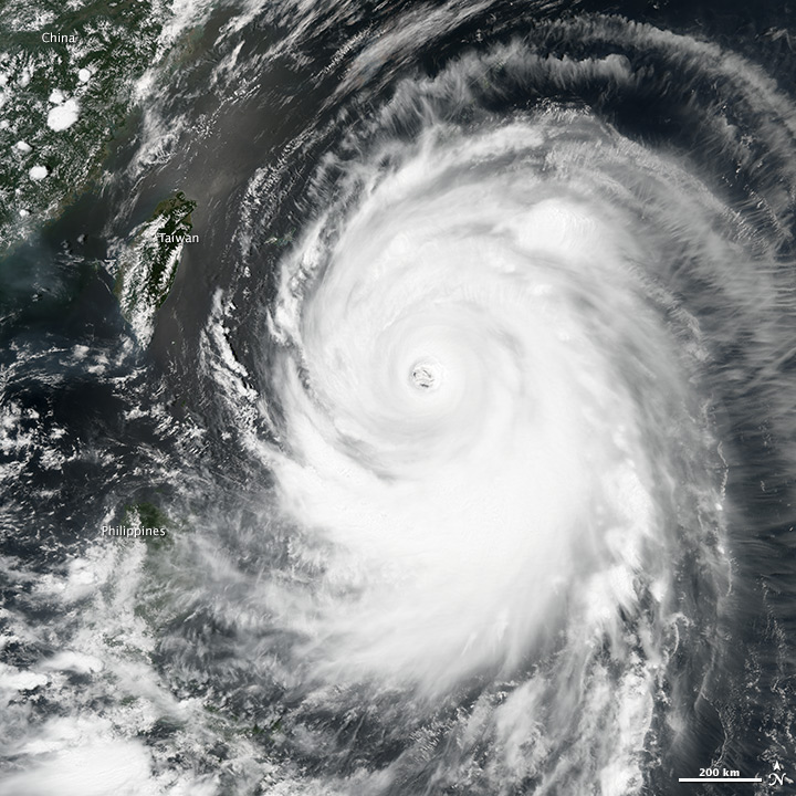
Typhoon Neoguri from NASA Earth Observatory picture of the day.
From the Japan Meteorological Survey's storm tracker webpage. Neoguri is predicted to start heading east and deviate along its current trajectory.
When I looked at the storm location forecast, I was curious about the deviation to the east. Luckily, I had my friend Leah (PhD student in Atmospheric Sciences at University of Utah) on gchat and asked her why the storm takes a sharp turn. Here is a brief, simplified explanation:
She explained that the shape of the polar jet stream creates a "trough" of colder air, which then acts as a sort of barrier to the hurricane's northward progress, pushing it eastward. This model shows some analysis and forecast of the behavior of the jet stream at the current and modeled conditions. The view looks down on the north pole and you can see Japan in the top left corner. The blue represent areas where the atmosphere is thinner (i.e. colder), and the reds represent areas where the atmosphere is thicker (i.e. warmer). At the intersection of the blues and the reds is the jet stream which tends to run around the northern hemisphere in kind of a sine wave pattern.
Additionally, this model shows how Neoguri could interact with the jet stream as it heads north. Neoguri is the little black dot that moves north from more equatorial latitudes up to Japan, then turns sharply east, once encountering the trough.
Model courtesy of University of Utah department of Atmospheric Sciences. Please note that these models from UU may only be available for the next month.
What are the conditions right now in Higashihiroshima (07/09/2014, 1500 local)? Hot (82F/28C) and humid (80%, miserable in any unit)! We quite a bit of rain on monday and a decent thunderstorm on monday night. Otherwise, things have been tame.
My neighbor buggin out from the rain on Monday.
I have plenty of food and water, some books and a headlamp for the worst case. The storm appears to be slowing so it may not hit until Thursday.
Here are some nice informative links regarding Neoguri:
Thank you to Leah for an excellent explanation and graphics for this post!

Thank you for this! I live in Hiroshima prefecture too and have been trying to look for information on typhoon Neoguri.
ReplyDelete